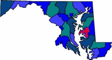


| Talbot County was named for Grace, Lady Talbot, the wife of Sir Robert Talbot, an Irish statesman. Talbot county has the longest shoreline of any county in the United States. Agriculture is the main industry. Soybeans, corn and wheat are the major produce grown. The Choptank River along with Tred Avon, Tuckahoe, Wye and Miles River allow for seafood and boat dockage. |
| Size: 477 Square Miles |
| County Seat: Easton |
| Government Form: Charter since 1973 |
| Population 2000: 33,812 |
| Median income for a household (2000): $43,532 |
| Median income for a family (2000): $53,214 |
|
| Talbot County Tourism |
| Talbot County Chamber of Commerce |
| Talbot County Government |
| Talbot County Public Schools |
| Talbot County Historical Society |
| Talbot County Library |
| Advertising Rates | Disclaimer | Site Map |
| Delmarweb, (Maryland) Copyright © 1997 - 2012 All Rights Reserved |