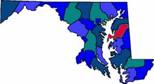
QUEEN ANNE'S COUNTY MARYLAND


Queen Anne's County Map

Queen Anne's County, located on the Easter Shore, was named for Queen Anne (1665-1714), who ruled Great Britain and Ireland from 1702 to 1714. This county includes the Bay Bridge and Kent Island, known as the gateway to the Eastern Shore. Today the county remains mostly farmland with few small towns and commercial centers. The Queen Anne's Museum of Eastern Shore Life has many artifact, household furnishings, farming and watermen's equipment from the past to the present. The Tuckahoe State Park, with 500 acres of parkland, offers scenic biking, hiking and canoeing on the lake and creek.

Size: 510 Square Miles
County Seat: Centreville,
Government Form: Code Home Rule since 1990
Population 2000: 40,563
Median income for a household (2000): $57,037
Median income for a family (2000): $63,713

Cities in Queen Anne's County

Centreville (21617) Chester (21619) Crumpton (21628)
Grasonville (21638) Ingleside (21644) Price (21656)
Queen Anne (21657) Queenstown (21658) Stevensville (21666)
Sudlersville (21668) blank blank

Queen Anne's County Resources

Queen Anne's County Chamber of Commerce
Queen Anne's County Government
Queen Anne's County Public Schools
Queen Anne's County Health Department
Queen Anne's County Library
Welcome To Queen Anne's County


Advertising Rates Disclaimer Site Map

Delmarweb, (Maryland)
Copyright © 1997 - 2012
All Rights Reserved