MONTGOMERY COUNTY MARYLAND


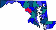
Montgomery County Map

Montgomery County was named after the Revolutionary War General Richard Montgomery (1738-1775). The county borders Washington DC. Know to be one of the most affluent counties in the nation. During the 19th century agriculture dominated the economy in Montgomery County. Montgomery County was important in the abolitionist movement.

Size: 507 Square Miles
County Seat: Rockwood
Government Form: Charter since 1948
Population 2000: 873,341
Median income for a household (2000): $71,551
Median income for a family (2000): $84,035

Cities in Montgomery County

Ashton (20861) Aspen Hill Barnesville (20838)
Beallsville (20839) Bethesda Boyds (20841)
Burtonsville Cabin John (20818) Chevy Chase
Clarksburg Colesville Damascus (20872)
Darnestown Derwood (20855) Dickerson (20842)
Friendship Heights Gaithersburg Garrett Park (20896)
Germantown Glen Echo (20812) Hyattstown
Kensington Laytonsville Montgomery Village
North Bethesda (20852) North Potomac (20878) Olney
Poolesville (20837) Potomac Rockville (20854)
Sandy Spring (20860) Silver Spring Spencerville (20868)
Washington Grove (20880) West Bethesda Wheaton

Montgomery County Resources

Montgomery County Home Page
Montgomery Community College
Montgomery County Government
Montgomery County Public Schools
Montgomery County Vistors Guide
Montgomery County Library


Advertising Rates Disclaimer Site Map

Delmarweb, (Maryland)
Copyright © 1997 - 2012
All Rights Reserved